For those who didn’t get a chance to read about my anxieties about getting lost in the woods but signing up to do a night orienteering race, anyway, you may want to go back and read Part I: A Trail Runner’s Attempt at a Navigation Race so you’re not completely confused. Speaking of confusion, before Eric, my navigation and orienteering badass supervisor, came to the park & ride where we met to carpool, I told him I was in the “right” parking lot. No, I was actually to his left from the direction he was coming from (and I had been to his house enough times to know this). Both Eric and I had a chuckle over it, but in the back of my mind, I felt like this was a prelude for what was to come.
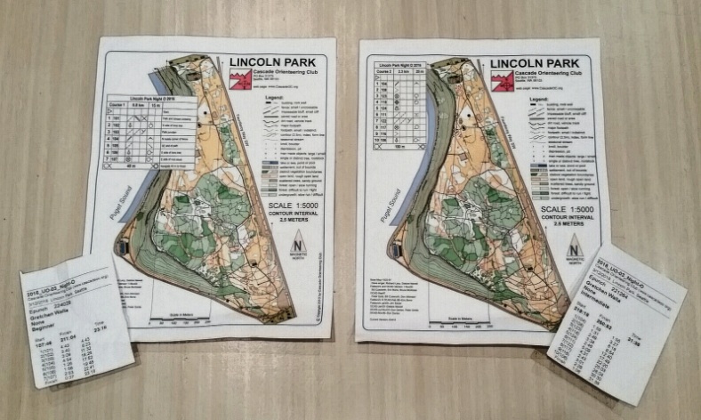
On the ride to Lincoln Park in West Seattle, Eric gave me an orienteering map of the park to familiarize myself with what the map symbols and colors meant. Orienteering maps are a work of art: they are beautiful, precise, and to a newbie, intimidating. Thankfully, I had been to Lincoln Park before, so I was able to visualize some of the features and locations shown on the map. Lincoln Park was also the site of the cross country championships in junior high in which I was leading the girls’ race and took the front pack the wrong way. We all had to backtrack up a hill, and—needless to say—I did not win. Not the best memory of Lincoln Park, but at least I know where the salt water pool is.
Once we got to the park, we registered me for both the beginner and intermediate courses. “So you have never done this before and you are doing a night course?” was most people’s reaction. I would look at Eric and say, “yep, he’s responsible for this!” Fortunately, we had enough time for Eric and me to do an informal practice course. He circled four locations on the map for me to visit in order and then showed me how best to hold the map and how to use the compass to orient the map and myself. “Ok, in order to get to the first checkpoint, what are some key features you will pass to get there?” I looked at the beautiful, detailed, complicated map and froze. “Well, wait, what do you mean?” Very patiently, Eric pointed out there were some main trails to get to the first marker and that it was near Fauntleroy Way, the main road bordering the park. We started walking in that direction, and once we reached the road, I didn’t know what to do. He pointed to the stone wall next to us and then pointed on the map that this is the feature he had circled. Next up, a tree at the south end of a parking lot. I easily made my way north along the road and found the tree he had circled. YES! Ok, the next location was a corner of a fence, which turned out to be a baseball field backstop that I could see from the tree. The last marker was the corner of a building. I got my myself and the map oriented to my location and walked back toward where we had started, locating the corner of the bathrooms on the way. OK, this wasn’t so bad!
When we got back to the registration table, I was elated to see Jordan Maki-Richards, a fellow trail runner who had also never done a navigation race and admitted to a poor sense of direction. While I believe Jordan when she says she sucks at reading maps, I also know this girl has no fear. She is an all-round badass athlete who was the first woman (and 6th overall) at the Orcas Island 100 miler at the end of February. However, like Eric, she is one of the most humble people you will ever meet. So I hatched the plan that I could do the beginner course with Jordan while Eric does the advanced course. Then Eric and I could do the intermediate course together and I could show him I knew what I was doing. Perfect!
Competitors could start their courses at two-minute intervals between 7:00pm and 8:30pm, with their race times being the difference between the start and finish timestamps recorded on their electronic punching sticks. With 20 minutes to spare before the course opened, we decided to wait in our cars because it was bone-chillingly cold outside! I told Eric of my plan, and he agreed it sounded good, since it would probably take around the same amount of time for Jordan and me to clear the beginner course as it would take him to do the advanced course. Eric and I got to the start area a little after 7:00, and as Eric got in line to start, I looked for Jordan. I couldn’t find her, so I waited around and took in the atmosphere. However, after about five minutes, I decided to head back to the car, because it was way too cold to just be standing around. I sent Jordan a text letting her know I was ready. However, after about 10 minutes, it started to dawn on me that maybe Jordan had already started. This was confirmed when I sent her another text and a few minutes later got back “Hey! Done! So fun! Headed home to pack for skiing tomorrow- thanks!” She had finished already?! That quick? Could I do a course that fast? What if it took me an hour or more to do what Jordan did in less than half an hour? She asked me how the intermediate course was, and we realized our miscommunication. I told her I hadn’t started yet, that I was waiting for Eric. About 15 minutes later, Eric finished his course. It took much longer than he anticipated (and it didn’t help that he was fighting a nasty cold) but that did not bode well for my current mood. I had had 50 minutes since the course opened to get into my head and let myself get chilled. By the time Eric got ready to head out with me, I was not in a good headspace, but there was no turning back now.
We walked up to the starting area, and I put my electronic punching stick in the box that cleared the memory in preparation to start. I was handed my map which showed purple circles for seven controls (“controls” is the term used for the locations that I had to find), then I punched the start box and was on the clock. I tried practicing the technique that Eric showed me earlier, but I was already flustered. Eric helped orient me to where I was and prompted me to identify features along the way that would get me to my first control. After what seemed like forever but in really was a little under 5 minutes, I found my first control (which had the serial number 101.) I stuck my electronic stick in the reader to record my time, then we were off to find the second control. I turned my body towards the direction of where I thought it was, and surprisingly, I was correct. We got back onto a main trail, and when that trail intersected with another, I looked to my left by a tree, and there was the orange and white marker flag bearing a punch box numbered 102. I distinctly remember this being a positive turning point because I didn’t need much guidance from Eric to find it. I turned my body in the direction of the next control, and off we went.
23:18 was my finishing time to find seven controls, not over an hour like I had visualized. Granted, Eric was with me and gave me some tips and guidance along the way. But it gave me the confidence and the drive to try the intermediate course. We just barely finished in time to head out for our second course, and around 8:30, we were off to find 10 controls. Eric and I took turns finding the controls, which I ended up thoroughly enjoying. I got to see Eric in his element and pick up tips on how he does things. When it was my turn to find a control, I had more confidence in where I was going, so we actually ran between controls! This is where I felt in my element. I find running at night on the trails exhilarating. When I knew where I was going, EVEN BETTER. Eric let me look for controls 4, 5, 6, and 7, which I found on my own. He took 1-3 and 8-10 some of which were located along small trails through the green areas that the map legend identifies as “forest: difficult to run / fight.” However, when we got close to where we needed to be, Eric would let me find the control. With determination, I would hunt around in the mud and brush until I found them, and dare I say I was having FUN doing so.
We finished the intermediate course in just over half an hour. While it would have taken me a lot longer without Eric on the second attempt, I knew I had done some of the course on my own. For someone who didn’t have the confidence before to tell you which way north was, that’s a win in my book.
The outcome: I will definitely do another navigation race. The thrill of trying to find checkpoints in a certain time frame just using a map and a compass is gratifying. I just need to convince Eric that the controls at our Nav Races should have chocolate waiting for competitors.
Want to give navigation races a try? Check out Mergeo Nav Races for a list of upcoming events. If you are still unsure or would like to more information, there will be a FREE Navigation Clinic for beginners on March 22nd at Seven Hills Running Store!